• Home
  • Buried Utility Surveying
  • PAS128 Utility Surveying
  • GPR Survey
  • Topographical Survey
  • Measured Building Survey
  • Case Studies.
  • More
    • Home
    • Buried Utility Surveying
    • PAS128 Utility Surveying
    • GPR Survey
    • Topographical Survey
    • Measured Building Survey
    • Case Studies.
  • Home
  • Buried Utility Surveying
  • PAS128 Utility Surveying
  • GPR Survey
  • Topographical Survey
  • Measured Building Survey
  • Case Studies.

    Utility Survey.

    At Plot. Surveys Ltd, we specialise in providing comprehensive and accurate utility surveys that are essential for the success of your infrastructure and development projects. Whether you are planning construction, excavation, or redevelopment, understanding what lies beneath the surface is crucial to mitigate risk, avoid costly surprises and ensure a smooth project work flow. Our skilled utility surveyors draw on experience from the full spectrum of sites that can be encounted. Our surveyors have a minimum of QCF Level 3 in Utility Mapping as standard.


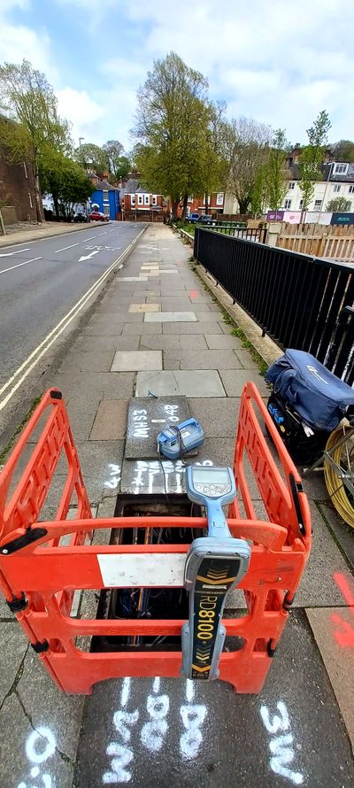
    A utility survey involves the systematic investigation and mapping of underground utilities and services in a particular area. This type of survey's primary aim is to identify, locate, and map the various utility lines such as water mains, gas mains, electrical cable routes, telecommunication lines, and sewer systems.


    These surveys are critical in construction and development projects to prevent accidental damage to existing utilities and avoid harm to those that work in close proximity to these buried services. By using a combination of ground-penetrating radar (GPR), electromagnetic locators (EML), and other latest technology we can create accurate maps and reports detailing the location and depth of these utilities. The information gathered from these surveys helps in planning, design, and execution of projects to avoid potential disruptions, accidents, or costly damage to essential infrastructure. Feel free to make contact if interested in this service.


    Why Choose Our Utility Surveys?


    • Advanced      Detection Technology: We use cutting-edge tools like Ground      Penetrating Radar (GPR) and Electromagnetic Location (EML) to accurately      detect and map underground utilities.
    • Expert      Analysis: Utilising our experience delivers detailed and reliable      data, allowing you to plan with confidence. The latest software is used      for processing of site data.
    • Safety      First: By identifying underground utilities before breaking ground, we      help you avoid potential hazards and costly project delays.


    From identifying buried pipes and cables to mapping complex utility networks, Plot. Surveys Ltd. is your trusted partner for accurate, detailed, and timely utility surveys.

    Need precise utility data for your next project? Contact us today and ensure your project is built on a foundation of safety and accuracy.
    Require a quote or have a query, please get in touch:

    Attach Files
    Attachments (0)

    This site is protected by reCAPTCHA and the Google Privacy Policy and Terms of Service apply.

    Contact Information

    1 Binscombe Lane, Farncombe, Godalming, Surrey, GU7 3PN, United Kingdom

    Email: info@plotsurveys.co.uk Phone: 07940419764

    Hours

    Mon

    08:00 – 17:00

    Tue

    08:00 – 17:00

    Wed

    08:00 – 17:00

    Thu

    08:00 – 17:00

    Fri

    08:00 – 17:00

    Sat

    Closed

    Sun

    Closed

    Plot. Surveys Ltd is committed to providing quality utility survey and land surveying services to our clients. We use the latest technology and equipment to ensure precise measurements and always deliver high-quality results. 


    Our services include:  Cable Tracing, CAT Scanning, Electromagnetic Locating, EML Survey, Geophysical Survey for Utilities, GPR Scanning, GPR Survey, GPR Surveyor, Ground Penetrating Radar, Land Surveys & Measured Building Surveys, Onsite Mark Ups, PAS 128, PAS 128 Specification Surveys, PAS 128 Utility Survey, PAS 128 Utility Mapping, Pipe Tracing, Pipeline Detection, Service Clearance, Topographical Surveys, Underground Utility Detection, Underground Utility Mapping, Underground Utility Scanning, Utilities Scanning, Utilities Survey, Utilities Surveyor, Utility As-built Surveys, Utility Clearance, Utility Locating, Utility Location Survey, Utility Mapping, Utility Marking, Utility Survey, Utility Surveyor, Void Detection. 

    Contact us today to discuss your project and see how we can help.


    Locations we cover: Aldershot, Bath, Basingstoke, Bournemouth, Brighton, Bristol, Cambridge,  Chichester, Crawley, Exeter, Gloucester, Godalming, Guildford, Horsham, Hove, Leeds, Leicester, London, Maidenhead, Oxford, Portsmouth, Reading, Sheffield, Southampton, Woking, Worthing, Winchester, York, Berkshire, Buckinghamshire, East Sussex, Hampshire, Hertfordshire, Kent, Surrey, West Sussex, Wiltshire, England, Wales, Scotland, Northern Ireland, UK, Ireland & Europe.

    Click Here To Discuss Your Survey Requirements Today

    Copyright © 2023 Plot. Surveys Ltd - All Rights Reserved.

    Registered in England No. 14535002

    Company Address: 1 Binscombe Lane, Farncombe, Godalming, Surrey GU7 3PN

    VAT No. 466 9696 18


    • Privacy Policy

    This website uses cookies.

    We use cookies to analyze website traffic and optimize your website experience. By accepting our use of cookies, your data will be aggregated with all other user data.

    DeclineAccept